The Geodesic Typeface

Par avion · The Geodesic typeface

17.46° N · 74.01° W · NYC

Geodesic: a typeface written by planes flying great circles

Every letter is the Earth, seen from one side. Every stroke is a plane flying the shortest route across it.

Drag any globe, or the dial, to turn them all at once. The routes stay on the map, and the far side shows through the Earth.

Over 17.46° N, 74.01° W (New York). Not rolled.

How it works

Every stroke is a flight

A geodesic is the shortest path across a curved surface. On a sphere it is an arc of a great circle, which is why long-haul flights bend on flat maps. Seen straight on, a great circle can only be the globe's rim, a straight line through the centre, or an ellipse touching the rim at two opposite points. Every stroke in Geodesic is one of those. No layovers, no lost luggage: every stroke is a nonstop flight.

P(s) = cos s · u + b · sin s · v
u = (cos θ, sin θ)   v = (−sin θ, cos θ)   b = cos(tilt)   0° ≤ s ≤ 180°

θ is where the route meets the rim, b is how wide it looks, and s is how far the plane has flown, so every stroke is four numbers: θ, b, s₀ and s₁. Because s is an angle at the Earth's centre, it is also distance: one degree is 111 km, and the O is one lap of the planet, 40,030 km. Frequent-flyer miles not included.

Every globe is seen from 17.46° N, on New York's meridian. From there the equator dips by sin 17.46° = 0.30 of the radius, the exact dip of the crossbars in the original drawing, so east–west strokes curve and north–south strokes stay straight.

Geodesic angles

Three angles fix every stroke: the heading θ where it meets the rim, the tilt that sets b = cos(tilt), and, on the Earth itself, the angle at which the route crosses the equator, which is also the farthest north or south it ever reaches (the readout beside the globe above shows it as you move the sliders). A plane on a geodesic never turns left or right, yet its compass heading keeps changing, because cos(latitude) × sin(heading) must stay the same for the whole flight: Clairaut's relation. Leave New York due east and the route slides south, crossing the equator at 40.7°, New York's own latitude.

Each glyph is a short list of flights, and each flight is four numbers.

A globe with a great-circle route leaving New York due east and crossing the equator at 40.7 degrees.

Glyphs

The alphabet

Capitals are the Earth. Lowercase letters are the Moon passing in front of it, seen from a spacecraft 257,000 km beyond the Moon, looking back at Earth. The Moon is only 27% of Earth's size, but from there it looks 68% as wide, and that sets the x-height. In b, d and h the Moon sits low on Earth's face; in g, p and y it sits high. Their stems are meridians of the Earth behind. Every lowercase letter is the Moon plus at most one Earth, and flights on the Moon go by rocket.

From out there you see the Moon's far side, pale and cratered, and you look along its orbit, never more than 6.7° from the lunar equator. So the bar of the e, the Moon's equator, dips only 12% where Earth's dips 30%. Hover or tap a letter to fly it and read its formulas.

Lowercase b, o and p: the Moon on the baseline, with the Earth behind it, the Moon low on Earth's face for b and high for p.
b, o and p. The Moon sets the x-height; the Earth behind it carries the stems, with the Moon low on its face for b and high for p.

Try it

Set some type

Capitals, lowercase, figures and punctuation in six weights, upright and italic. The italic is the same view rolled 12° about your line of sight, so every globe stays round. Please return your seat back to the upright position, unless you've pressed Italic.

Italic also opens the italic lab: drag any letter and every globe turns with it, any way you like, with the turn read out as one axis and an angle.

Press Let's fly and the planes write whatever you've typed.

Origin · 2012–2026

Drawing a typeface with planes

I've spent a lot of hours on planes watching the little map on the seat-back screen, the route a long arc bending toward the pole with the plane icon creeping along it. Then I'd look out the window and see clouds. What if you could draw massive letters just by flying?

From the seat it feels like you're flying straight, and you are: the plane never turns left or right. The Earth curves under you, so the straightest line on a sphere is a great circle, and it's also the shortest. Flatten it onto a map and the shortest route looks bent, while the line that looks straight is the long way round. New York to Tokyo along the great circle is 10,852 km, up past 69.9° N over Alaska. Holding one compass heading, the map's straight line, it's 12,792 km.

d = R · arccos(sin φ₁ sin φ₂ + cos φ₁ cos φ₂ cos Δλ)
R = 6.371 × 10³ km   φ = latitude   Δλ = difference in longitude

Seen from one side, every great circle is the globe's rim, a line through its centre, or an ellipse touching the rim at two opposite points. So every stroke is four numbers, and that's the whole typeface.

Around 2012 I was editor-in-chief of Wander: Brandeis Abroad, a journal of writing and photography by students studying abroad, and I used the idea for its masthead. I drew the letters by hand, then traced them digitally. While I was drawing them I asked a math PhD friend whether the curves could be plotted as real flight paths. They could, but it would take far too long, so I eyeballed them.

In 2026 it took a few hours with Claude Opus 5.5, after earlier AI models fell short. Claude traced the old drawing, fitted every stroke to a true great circle, and drew the rest of the alphabet by the same rules, lowercase included. Drag across the drawing below to see how close my eyeballing got.
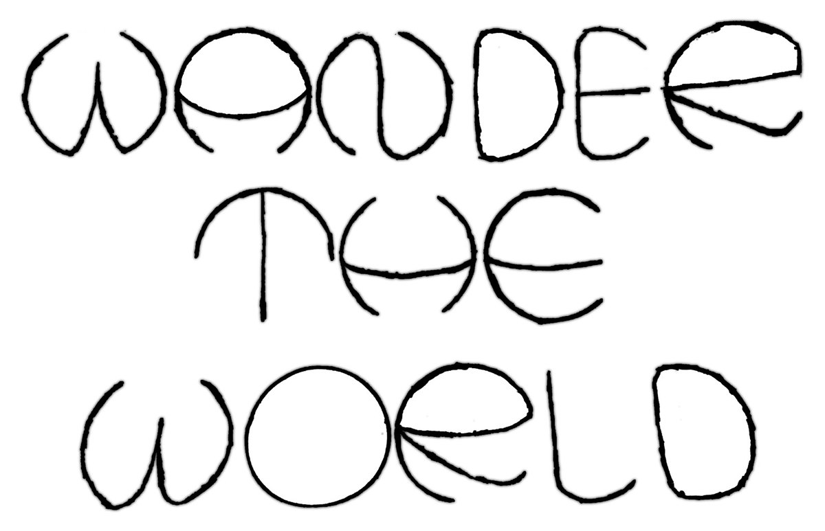
The hand-drawn 2012 lettering: WANDER THE WORLD, each letter built from circular arcs. 2012 drawing Fitted flight paths
Drag the divider. Left: the 2012 drawing. Right: the true great circles closest to each drawn letter, with each letter's globe in blue.